After two summers working in Glacier National Park, I’ve hiked hundreds of miles of trails. This is my ultimate compilation of Glacier’s best day hikes.
Know Before You Go
Preparation and Safety (please read!)
When planning your trip to Glacier, take seasonal closures into account. Trails at high elevations are often closed into July. Some hiking bridges are taken down during the off-season. The National Park Service might unexpectedly close trails due to wildlife activity or other variables. Monitor trail conditions on the official National Park Service website, or stop into a ranger station in the park.
The Going-to-the-Sun Road also experiences seasonal closures and requires vehicle entry permits during peak season. Many Glacier Valley has construction beginning in 2025 that severely limits road access.
Always carry bear spray. Prepare for rain, intense wind, and even snow in the middle of summer. Weather can change on a dime in the mountains.
And, as always, leave no trace!
Avoiding the Crowds
The obvious way to beat the crowds is to get to the trailhead before 6am. Alternatively, I used to hike after I got off work at 2:30pm, and I found that many hikers clear out by dinnertime. Parking usually starts to open up at Logan Pass around 5pm. So, if you’re doing a shorter hike and don’t need the entire day, try starting in the evening. The summer sunset is late in northern Montana, so take advantage of it. *Except be careful of trails that are commonly promoted as “sunset hikes,” such as Hidden Lake Overlook.
Of course, this list is of the most popular trails in the park, so you have to accept that they will generally be crowded.
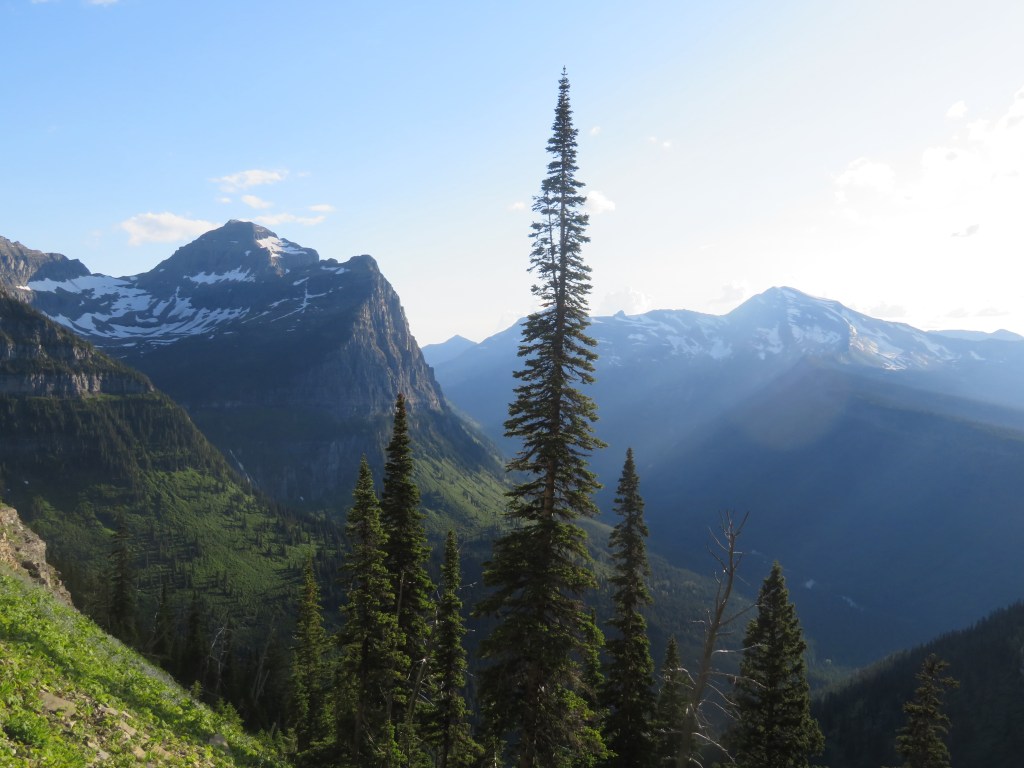
West Glacier
Trail of the Cedars to Avalanche Lake

5 miles, 700 ft elevation
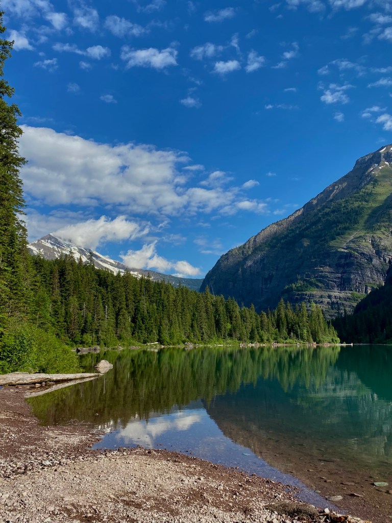
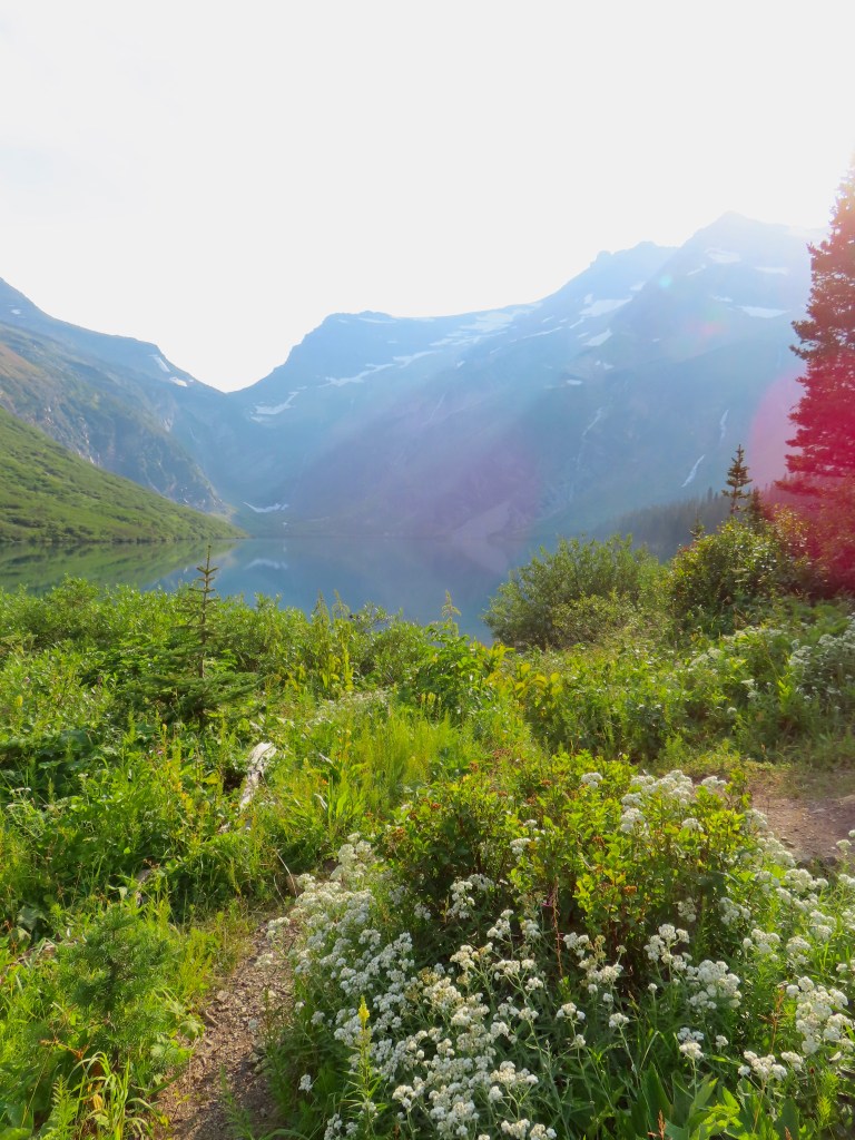
Listed on AllTrails as the #1 hike in Glacier, Trail of the Cedars to Avalanche Lake is one of the park’s most popular trails for good reason. The trail begins at Avalanche Campground on the wheelchair-accessible boardwalks of the Trail of the Cedars. The dense, old-growth forest has a quiet beauty, the trail meandering alongside the turquoise waters of Avalanche Creek. There are not many grand views along the journey, but it makes the reveal of Avalanche Lake all the more rewarding. There are beaches scattered around the lakeshore, so you may find a quiet spot to rest even during peak season. Some hikers take the overgrown path to the far end of the lake for a different perspective, though I think the first view of the waterfalls is the best.
East Glacier
Saint Mary and Virginia Falls


3 miles, 450 ft elevation
This is one of my favorite hikes during June in Glacier, and I always bring a rain coat for the spray from Virginia Falls! I usually stop recommending this trail by late July when there is less snow runoff. There are several small trailhead parking areas at the west end of Saint Mary Lake on the Going-to-the-Sun Road. The beginning of the trail has views of the beautiful Saint Mary Lake on the way to Saint Mary Falls. Every summer, my coworkers can be found jumping off the bridge into the river at Saint Mary Falls, but please use extreme caution if you decide to do so. Glacier’s waterways are frigid and have unpredictable currents, making drowning the highest cause of death in the park. Past Saint Mary Falls, the trail climbs upstream along Virginia Creek. Upper Virginia Falls is truly the grand finale of the trail, but be sure to check out the viewpoint of Lower Virginia Falls as well.
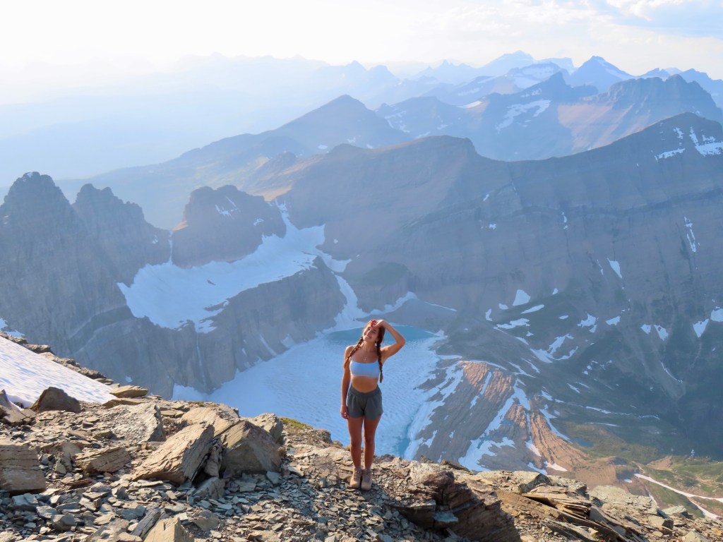
Gunsight Lake
12.5 miles, 1500 ft elevation
I never see this listed as a day hike, and I advocate that more people should do it! From Jackson Glacier Overlook, take the Gunsight Pass Trail to Gunsight Lake. The trail descends into a valley and passes a marshy area frequented by moose. I feasted on plentiful huckleberry and thimbleberry bushes along the trail in early August. One of my favorite features of the trail is its view of Mount Jackson, one of Glacier’s six peaks over 10,000 feet. (I actually summited Mount Jackson this day.) As the trail climbs toward Gunsight Lake, there is an incredible view of Jackson Glacier and Blackfoot Glacier. I did this hike on a smoky day, so my photo of Gunsight Lake has a blue haze, but it is truly gorgeous.
*I have not done the full 20 miles of Gunsight Pass, but I will add it to this post when I do! Most people backpack 1-2 nights, but it is possible to complete the trail in a day if you are a strong hiker.
Logan Pass
The Highline

The Highline Trail begins at Logan Pass and heads north into Canada as part of the Continental Divide Trail. There are two main out-and-back hikes on the Highline, and I also included it in two point-to-point hikes later in this guide. There are breathtaking views along the entire Highline Trail, making it popular with hikers, bighorn sheep, and mountain goats alike. (Read more of my tips about where to spot wildlife in Glacier National Park.)
Highline Trail to Haystack Butte: 7.5 miles, 1,100 ft elevation
Haystack Butte is a good turnaround point because it is just past Big Bend, one of the best views in Glacier, and the trail’s first glimpse of West Glacier is just over the saddle. Some people take the spur trail up to the top of the butte, but I don’t think the viewpoint is particularly better than the view from the trail. I like to do this as a sunset hike, as many hikers have cleared out from the parking lot and trail by then.
Highline Trail to Granite Park Chalet: 15 miles, 2,600 ft elevation
I prefer doing the Highline to Granite Park Chalet as a point-to-point hike, but this option avoids the need for transportation between two trailheads. 6.5 miles in, there is a spur trail to Grinnell Glacier Overlook. It is very challenging, climbing 1,000 feet in a mile, but the view is well-worth the effort. Bring cash to Granite Park Chalet to buy a snack or a cold Gatorade.
Hidden Lake Overlook

3 miles, 550 ft elevation
Beginning at Logan Pass Visitor Center, the hike to Hidden Lake Overlook is one of the best places in Glacier to see mountain goats and bighorn sheep. You get a lot of bang for your buck on this short and easy hike. Much of the trail is a boardwalk with intermittent stairs to the overlook. The trail continues down to the base of Hidden Lake, though most visitors (including myself) turn back at the overlook.
Many Glacier
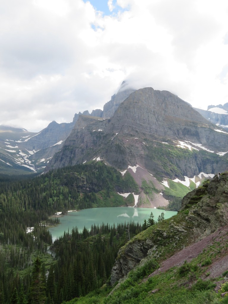
Grinnell Glacier

10 miles, 2,000 ft elevation
The trailhead has a small parking lot between Many Glacier Hotel and Swiftcurent Motor Inn. Additional parking is available at Many Glacier Hotel, only adding a short, flat walk around the lovely Swiftcurrent Lake. In July and August, the Glacier Park Boat Company runs tours across Swiftcurrent Lake and Lake Josephine, shaving a couple miles off the hike. The long ascent begins at Lake Josephine, passing the iconic overlook of Grinnell Lake on the way to Grinnell Glacier. This is by far my favorite hike in the Many Glacier area, rivaling even the Highline Trail.
Grinnell Lake

7 miles, 450 ft elevation
The Grinnell Lake hike begins at the same trailhead as Grinnell Glacier, diverging around Lake Josephine before the elevation begins. Many hikers combine the two trails for a long day hike. Grinnell Lake is (literally and metaphorically) overshadowed by the Grinnell Glacier trail, and, in my opinion, deserves as much praise as Avalanche Lake. This hike is also made significantly more accessible by the boat tour, though no footstep is wasted on this stunning trail.
Iceberg Lake

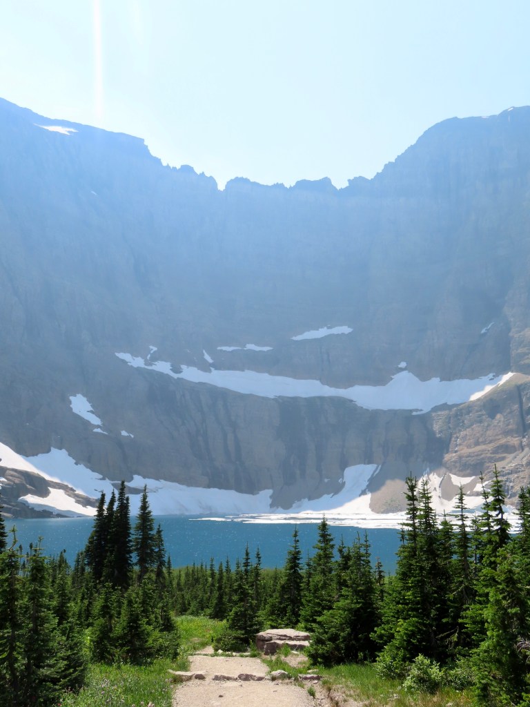
10 miles, 1,400 ft elevation
As pictured above, Iceberg Lake may be covered in ice in early June and have hardly any icebergs left come late July. Iceberg Wall is always impressively imposing, casting a shadow over the lake in the evening. The Iceberg Lake trailhead begins behind Swiftcurrent Motor Inn. The first half-mile is a steep slog, but the rest of the trail has only gradual elevation change and delightful views of Swiftcurrent Valley.
Iceberg Lake and Ptarmigan Tunnel: 15 miles, 3,000 feet
Since Iceberg Lake and Ptarmigan Tunnel share a trail for the first 2.5 miles, they’re a great option to combine. If you prefer to do the hard part first, that would be Ptarmigan Tunnel.
Ptarmigan Tunnel

10.5 miles, 2,350 elevation
After breaking off from Iceberg Lake trail, there is consistent elevation gain up to Ptarmigan Tunnel. The trail is somewhat forested, providing shade but not too many good views until you reach Ptarmigan Lake. Be sure to check ahead of time whether the tunnel has been opened for the season, as you won’t be able to see it until you’ve climbed the final brutal switchbacks and are standing right in front of the steel door. (I learned this the hard way.) Once you’ve gone through the tunnel, Elizabeth Lake is in the valley below, and Old Sun Glacier is to your left. You have to walk further down the trail to see the glacier appear from behind the mountainside, but, be warned, the trek back up is steeper than it looks.
Cracker Lake
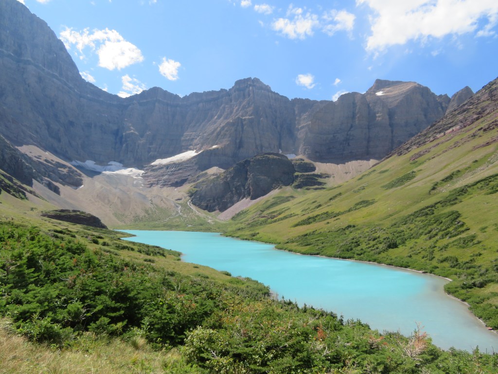
12.5 miles, 1,600 ft elevation
This hike is about the destination, not the journey. The Cracker Lake trailhead is at the far end of the Many Glacier Hotel parking lot. The trail is heavily forested and used by the Swan Mountain horseback tours, which means horse droppings. Nonetheless, Cracker Lake is still regarded as one of the best hikes in Glacier because it has the bluest glacial water of any lake in the park. The strenuous hike prevents the lake from getting too crowded, making it a pleasant spot to spend an afternoon. If you can brave the icy water, there are many rock ledges on the far end of the lake for cliff jumping.
Swiftcurrent Pass to Redrock Falls and Bullhead Lake


7 miles, 400 ft elevation
The Swiftcurrent Pass trailhead is at the end of the Swiftcurrent Motor Inn parking lot. The hike to Bullhead Lake is as flat as it gets in Glacier, meandering along a chain of lakes in Swiftcurrent Valley. Less than a half-mile in, there is a short spur trail to Fishercap Lake, one of the best places to spot moose in Glacier. Some hikers turn around at Redrock Falls, located at the far end of Redrock Lake, for a 4-mile roundtrip. I think Bullhead Lake is the best of the three lakes and worth the extra distance.
Point-to-Point Hikes
These day hikes traverse multiple regions of the park.
Siyeh Pass


10.5 miles, 2,200 ft elevation
Siyeh Pass is so underrated! I did this hike on an afternoon in late July and barely passed another soul (though that could be attributed to our starting a 10-mile hike at 4pm). We parked at Baring Falls and took the free NPS shuttle to the trailhead at Siyeh Bend, so our car was waiting at the end of our hike. Hiking from Siyeh Bend to Baring Falls is my preferred direction, as it has 1,000 less feet of elevation gain. The trail has a great variety of views from the charming valley beneath Mount Siyeh up to the rugged mountain pass. Heading down the other side of the pass, there is an expansive view toward Saint Mary Lake below with Sexton Glacier to your right.
Highline Trail to the Loop

11.5 miles, 1,400 ft elevation
This is the best route to hike to Granite Park Chalet. I recommend parking at the Loop and taking the shuttle up to Logan Pass, as it’s nice to finish the hike at your car. From Logan Pass, hike the Highline Trail to Granite Park Chalet. A half-mile before the chalet, there is a spur trail to Grinnell Glacier Overlook. The overlook is my favorite part of the trail, well-worth the additional 1,000 feet of elevation. After taking a break at Granite Park Chalet, descend the much steeper 4-mile Loop Trail down to the Going-to-the-Sun Road. The Loop Trail is partially forested, but there are sections with mountain valley views.
Highline Trail to Swiftcurrent Pass


15 miles, 2,000 ft elevation
The final trail on my list is both the most difficult and my favorite. Begin at Logan Pass and hike the Highline Trail to Granite Park Chalet. Then, take the Swiftcurrent Pass trail down into Many Glacier. Logan Pass is at a significantly higher elevation than the Swiftcurrent Pass trailhead, so this direction saves you some effort.
If you need transportation to the trailhead, ask at Swiftcurrent Motor Inn or Many Glacier Hotel about taking the Xanterra shuttle to Saint Mary Visitor Center. From there, take the NPS shuttle up the Going-to-the-Sun Road to Logan Pass. The hike will end back at the Swiftcurrent Motor Inn parking lot (and Nell’s is right there for dinner!).
Including the Overlook and Peak: 20 miles, 4,400 elevation
While the Highline Trail and Swiftcurrent Pass are enough to satisfy any hiker, I always add the spur trails to Grinnell Glacier Overlook and Swiftcurrent Peak. They are extremely challenging, each one climbing approximately 1,000 feet of elevation in a mile, but isn’t the reward sweeter when you have to work for it? If you can only add one, Grinnell Glacier Overlook is probably the more beautiful view. However, standing on top of a mountain peak is an unbeatable sensation, and I think the Swiftcurrent Fire Lookout is a cool place to visit.
